

McCullough Peaks
Difficulty: 2 - 3
Time to Complete: 4 hours
Distance: 11.3 miles round trip
Seasonality: Year-round
Fees/Permit: No
Dog Friendly: Yes
Destination Highlights: Solitude close to town; multi-layered geology; easy peak bag
Summary: This is a popular local hike in the badlands east of Cody. With over 25,000 acres of BLM land to explore, hikers can choose to walk on the quiet dirt road or on the many miles of singletrack trails winding through the sage covered hills.
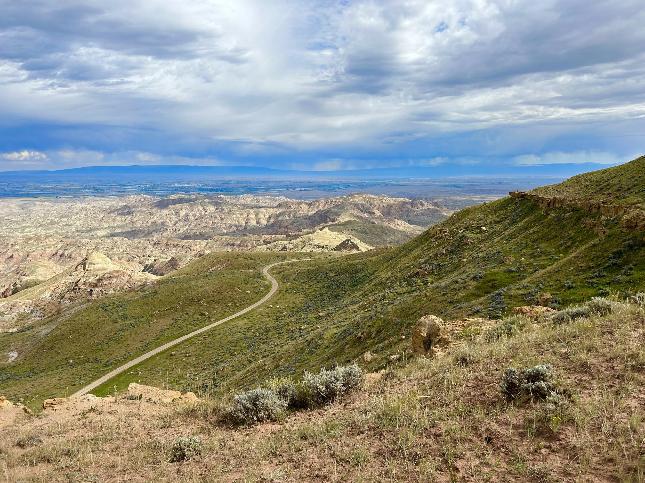
Although close to town, the rugged badlands of McCullough Peaks bring solitude.
Like the classic “Fells” hillwalking routes in England, where locals climb multiple peaks in one morning, Cody has its own version of the Fells. At McCullough Peaks, it’s possible to climb at least three different peaks in one 5.5-mile route. From the bottom of the steep incline on McCullough Peaks Road, leave the main road (and the car) and look for an old road bed in the grass to the northeast. Hike the double track through a dry gulch and then follow it up a gentle spine with dry drainages on either side. It’s just one mile to the top of the ridge. Once on the top, briefly rejoin the main road to begin a hill climbing circuit. First, aim for the unnamed 6,400 foot peak to the north. Leave the main road and follow the path along the ridge top and over a barbed wire fence to reach the first peak. A rock cairn and three metal fence posts mark the summit. Continue down the northeast face of the peak, following the clear trail as it skirts around another climbable peak and then heads downhill to join the main road again. Next, aim for the antenna-covered 6,547 foot peak to the east. To reach it, follow the main road as it grades around to the north, but pick a strategic spot to proceed off trail to the summit. At the top, avoid the off-limits fenced section, but look for the USGS survey post at the high point. Finally, head for the crown jewel of this hike, the true McCullough Peak summit, standing alone in the southeast. Rejoin the main road to approach the base of the peak, and then proceed off trail to reach the top. Look for the round USGS survey marker from 1950 that marks the summit. Take a break on the mountain top to enjoy clear views across the Bighorn Basin to the Pryors and Bighorns. On a clear day, it’s possible to spot distant Index and Pilot peaks in the Beartooths near Cooke City.
What Makes It Great: From the McCullough Peaks summits, scan the horizon to the east for as many as 170 wild horses in the badlands. The BLM’s Wild Horse Herd Management Area includes over 100,000 acres just to the east of McCullough Peaks. In addition, pronghorn, mule deer, bald eagles, and hawks enjoy this diverse and desolate landscape.
Who is Going to Love It: Except when snow and ice cover the roads and trails, the McCullough Peaks area is accessible year round. Hikers of all ability levels can enjoy this natural area close to town. Each season at McCullough Peaks provides a different experience, with clear blue skies in February, high grass and wildflowers in June, and fall colors in October. Anyone who prefers a shortened version of this hill climbing circuit could opt to drive the road sections and hike each peak, or complete the hike as a point-to-point.
Directions, Parking & Regulations: From Cody, head east on the Greybull Highway (WY-14) for six miles. Just at the edge of town, turn left on McCullough Peaks Road, which is directly across the highway from the Cody Archery Range. Follow the good dirt road for five miles and then park in the turnout at the left side of the road just before the steep uphill section. McCullough Peaks Road is suitable for passenger vehicles, but can become treacherous when wet or icy. Dogs are welcome but should be kept under control because of wildlife in the area. Hikers should be sure to check the brown trailhead markers for instructions from the BLM. Some routes are closed for habitat rehabilitation. Cell phone service is available throughout this hike.