

Sheep Mountain Trail

Summary
This is a great trail that’s close to town but gives you a true wilderness experience. From the summit, the views of Cody and the entire Big Horn Basin are spectacular.
DIFFICULTY: 3
DISTANCE: 6.3 miles, loop
TIME TO COMPLETE: 3 hours
SEASONALITY: Late Spring, Summer, Fall
DOG FRIENDLY: Yes
FEES/PERMITS: No
DESTINATION HIGHLIGHTS: An island of high-altitude wildflowers and views close to Cody
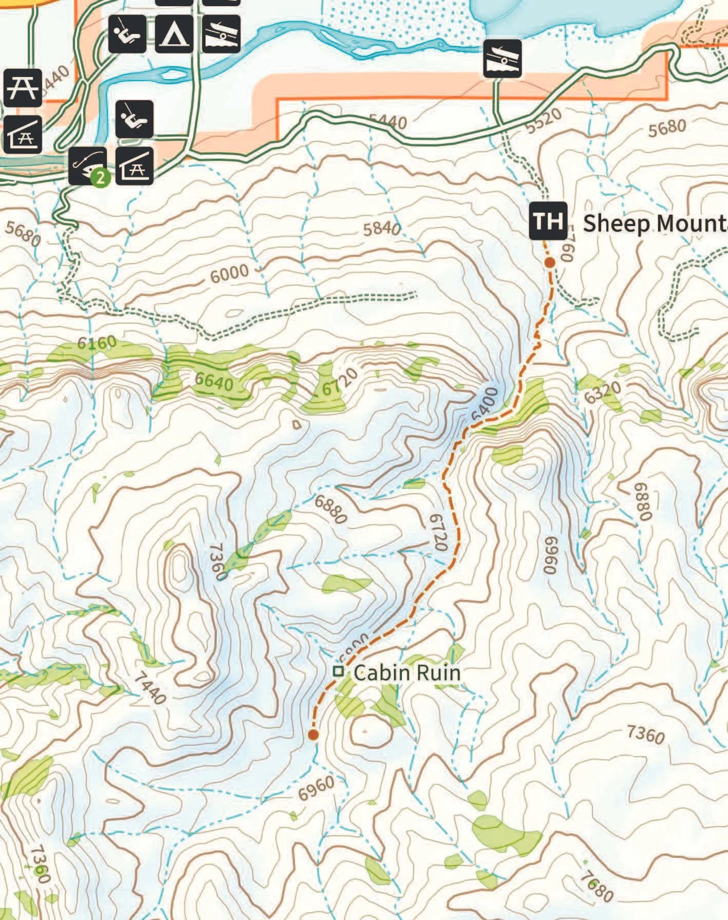
Map Courtesy of Natural Atlas
Intro
The Sheep Mountain trail is ideal for a half or full-day hike in the wilderness. You will hike through the sagebrush steppe, a narrow canyon, and stunning wildflower meadows, all within a relatively short distance. Despite being a popular trail, you will likely encounter few people. The mid-portion of the trail is steep but with good switchbacks, and you will soon be rewarded with fantastic wildflower viewing.
What Makes It Great
The views from the top of effort worthwhile. From this vantage point, you can see north to Heart Mountain and the Pryor Mountain Range in Montana, 50 miles east to the Big Horn Mountains, and 30 miles south past the Meeteetse Rim. This is wide, open country, and Cody seems like a pretty small dot below you. The trail begins on the sheltered north side of Sheep Mountain, where you’ll traverse some sagebrush and pinyon pines. Within the first mile, you’ll enter a canyon of light-colored limestone with cliffs rising several hundred feet above you. The trail becomes steep at this point for a short distance until you top out into a lush wildflower and grass meadow. The trail starts to fade out through the meadow, so continue south along the drainage, and you'll come to an old cabin in another mile. This marks the official end of the trail. From here, you can wander around checking out the view or head to the actual summit if you have a GPS unit handy. The coordinates for the summit are 044° 26’ 32.51’’ N, 109° 19’ 41.75’’ W. Sheep Mountain is one of those typical western hills that has several apparent summits.
Who is Going to Love It
Those who would enjoy a changing display of local wildflowers while taking in the unique basin and range topography. Three rare plant species, including Absaroka beardtongue, Absaroka biscuit root, and Aromatic pussytoes, can be found on the mountain. The area offers a great hiking experience for those short on time and presents an opportunity for history buffs to imagine the winter lifestyle of the original inhabitants, the Shoshone Indians, who relied on Bighorn sheep for sustenance. Sheep Mountain is actually a part of Heart Mountain, which geologists believe detached from its parent rock and slid onto the Big Horn Basin, leaving behind Sheep Mountain and the McCullough Peaks as remnants of this event.
Directions, Parking, & Regulations
From Cody take the North Fork Highway or US Highway 14/16/20 west to the far end of the Buffalo Bill Reservoir. Turn left towards the Buffalo Bill State Park campground. Drive south .5 miles then turn left (east) onto Stagecoach Trail. Continue on the gravel road for 1.0 miles then turn right (south) at the Sheep Mountain Gravel Pit sign. There is plenty of parking for several vehicles, including horse trailers. The information kiosk marks the trailhead.
This is BLM land so dogs are allowed if they’re leashed. Remember, this is grizzly bear country so take your bear spray and hike in groups of at least three people. You might also hear the buzz of a rattlesnake on this trail.
This hike is an excerpt from Sunlit Trails, our locally written guidebook to hiking in Northwest Wyoming and Yellowstone. If you’re looking for more trail inspiration, maps, and local insight, you can pick up a copy in-store, online, or at Legends Bookstore in Cody.