

Clocktower Creek: A Great Day Hike, or First Overnight Trip


Length: 2 miles out and back
Time: 2 hours
Difficulty: Easy
Best Season: Spring and Fall
Trail Users: Hikers and Hunters
Pets: Pet-friendly
Fees: None
Access: Forest Service land from highway
SUMMARY
A short, enjoyable hike through a scenic valley that’s an immersive trek for the new backpacker and a pleasant outing for the more experienced.
INTRO
The North Fork certainly has no shortage of cheerful brooks, astounding rocky spires or stunning views, but the Clocktower Creek trail is one of the best places for all three. Nestled in between beautiful Ptarmigan Mountain and the wide reddish spire that gives the creek its name, this secluded little valley is home one of the most delightful, easy hikes in Wyoming. Kids will have no problem with the creek crossing, animal tracks, or leisurely pace.
WHAT MAKES IT GREAT
The Clocktower Creek trail’s breathtaking scenery might be the headline, but the easygoing nature of the trail is the real reason to head out, giving you time to really experience the hike.
WHO IS GOING TO LOVE IT
Comfort-oriented campers, kids, and new hikers will all value this short, fun-filled hike, plus the excellent camping grounds.
DIRECTIONS, PARKING & REGULATIONS
There’s a few different ways to get to the great campsites on Clocktower Creek.
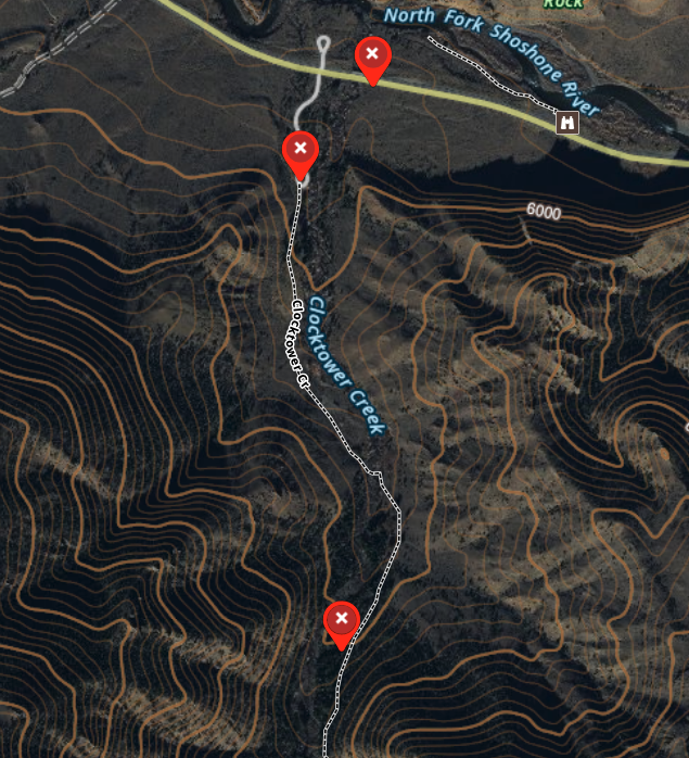
If you would like to take a more scenic route, didn’t bring sandals, or just don’t want to get your feet wet, pull over just before the Clocktower Creek Bridge at milepost 24.84. Start hiking south, uphill and just to the right of where a small ridge comes down to meet Clocktower Creek. There is a trail that leads up the drainage, just off of the end of the ridge. Stay well above the creek, and pass under a large, fallen tree. Follow the trail as it winds its way up a small valley, until you intersect a very well defined trail that comes in from your right. From this point, follow the description below from the point just after the creek crossing.
If you would like a very easy to follow route and don’t mind a creek crossing, turn left up Forest Service Road 477, just past the Clocktower Creek bridge at milepost 24.84. Follow this road 0.2 miles south to a small parking area, being careful to not block the gate. Walk through the gate and follow the dirt road 0.25 miles. At this point the road curves to the right – and the trail keeps going straight. Follow the trail another quarter of a mile to a crossing of Clocktower Creek. Most of the year, this is a very shallow stream. Be careful during the spring and early summer as the flows increase markedly. Continue past the creek and up onto a small bench.
From the point just after the creek crossing, the trail is very easy to follow. There is one major fork not long after the crossing – keep to the right, nearer to Clocktower Creek.
If you are day hiking, the trail continues up and into the trees in the next half of a mile. The trail itself continues along – and across – Clocktower Creek for a significant distance. It’s easy to spend a whole day up the drainage.
If you are out for a short overnight backpack, there is a fantastic site along this trail that offers a great camping experience. This site is close enough to the road for easy access if everything doesn’t go to plan, but far enough away to give a true wilderness experience. From the spot where the two trails come together (just after the creek crossing), continue south 500 yards along the trail. Keep an eye out on the right – you will see a large, flat campsite with an established fire ring and plentiful spots for a tent. The creek is just past the site, over a small rise. This spot is marked on the below map – it’s the southernmost waypoint.
Remember, this is bear country. Make sure that you take your bear spray. If you are staying overnight, follow all of the usual guidelines about where to cook and how to handle your food.